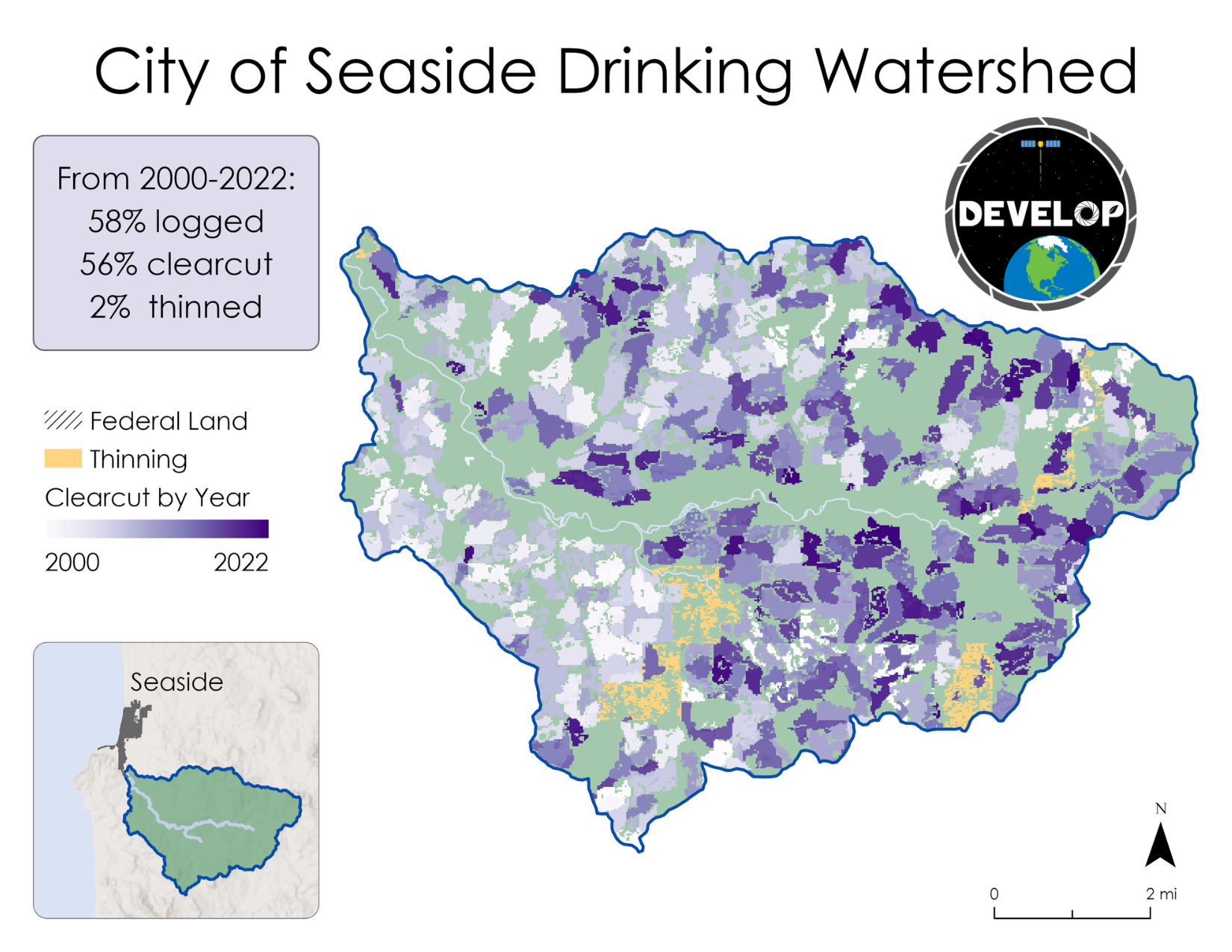
Today, the NASA DEVELOP Program released an analysis of how much of Oregon’s Coast Range was logged in the past 20 years in drinking watersheds. The maps and analysis show clearcutting across substantial portions of these watersheds.
Logging operations are widespread across the Oregon Coast Range and conventional practices pose a big risk to surface water quality. In a state where surface water accounts for ~70% of all water use, forests are vital in protecting drinking water from contamination.
— NASA DEVELOP (@NASA_DEVELOP) September 12, 2023
"The team’s analysis on clearcutting found that 26% of the forested area within the 80 selected watersheds experienced clearcutting between 2000 and 2022," said the report. "This is equivalent to approximately 584 square miles of land.... or 25 square miles, per year."
The 584 sq miles of clearcutting in the Coast Range is only the amount in drinking watersheds, it doesn't factor in the rest of the mountain range. Many of these forests have been clearcut more than once.
“Anyone that has driven through the Coast Range has seen the jarring clearcuts. Now, one of the premier scientific agencies on the planet has demonstrated just how extensive that logging has been,” said Erik Fernandez of Oregon Wild. “Seeing that several watersheds have had over 50% of their drinking watershed logged was of particular concern.”
The report is the result of a NASA DEVELOP 10-week assessment study co-developed with Oregon Wild.
Key statistics from the NASA report
|
Studies have demonstrated that clearcut logging, as well as the practices that accompany it, like road building and aerial pesticide spraying, increase sediment and other pollutants flowing into streams and drinking water sources. While the recent Private Forest Accord increased no-logging buffers around streams and added some protections for steep slopes, communities remain concerned about the extent of clearcutting in their drinking watersheds and short-term and cumulative impacts of industrial logging. The Oregon Department of Environmental Quality is responsible under the federal Clean Water Act for protecting water quality.
“Companies are logging a vast landscape–both public and private land–that people depend on for drinking water, treating the forest like a crop rotation instead of the complex and living system that it truly is,” said Casey Kulla, state forest policy coordinator for Oregon Wild. “In the Coast Range, Oregon’s Department of Environmental Quality needs to be focused squarely on protecting the quality and quantity of water from these forests. Polluters need to be held accountable for known water quality failures.”
![]()
Beyond issues with water quality, clearcut logging has also been shown to decrease the quantity of water available for decades after the logging occurs. When a forest is cut, the roots of the trees begin to break down and the soil no longer stores moisture over time, so water drains out of the clearcut more rapidly, creating high-intensity pulses. The young, growing forests that are planted in the wake of a clearcut take up vast amounts of water, which can leave downstream communities in drought, such as what happened to Yachats in 2015.
Cities and rural cooperative water associations along the Oregon Coast Range are highly motivated to purchase their drinking watersheds to manage the land primarily for water quality and quantity. Unfortunately, forestland in the Coast and Coast Range remains prohibitively expensive for many communities and state agencies have been slow to respond to the threat of degraded drinking watersheds from logging. In the 2023 legislative session, the Oregon Legislature directed $5 million to community drinking watershed purchases.
“Oregon legislators deserve credit for taking steps that support communities working to protect their drinking water,” said Kulla. “However, more funding is needed for these critical purchases. We hope this analysis from NASA highlights the importance of these investments and that Legislators representing rural communities in the Coast Range and elsewhere will be leaders on this issue in Salem.”
The NASA/Oregon Wild project area primarily encompassed industrial forestlands (owned by Weyerhaeuser, Roseburg Forest Products, Stimson, and others) as well as state, federal, tribal, and municipal/county-owned lands. Private lands logging is typically clearcut logging whereas public lands logging is a mixture of thinning and clearcut logging.
Coast Range residents who want to stay informed about what happens in their drinking watersheds can sign up for the Oregon Department of Forestry’s notification system, FERNS. For a step-by-step tutorial, visit Your Forest Watershed and sign up at the Oregon Department of Forestry's E-Notification page.